A timely reminder given the now very convoluted discourse about China because of our renewed, refreshed, “special relationship” with the US.
The frame of reference for the 1900 Treaty of Washington’s definition of the Philippine territory was the Murillo Velarde map, which included the Spratlys and the Scarborough Shoal, But still, China’s position is that Philippine territory is limited to the islands enclosed by the polygonal lines drawn in the 1898 Treaty of Paris. Justice Carpio said that China did not participate in the Arbitral proceedings, but “by officially submitting its Position Paper to the Arbitral Tribunal, China expressly and formally recognized that Philippine territory is defined by three treaties, including the 1900 Treaty of Washington… China is forever estopped from claiming that Philippine territory is limited to the islands enclosed by the Treaty of Paris.”
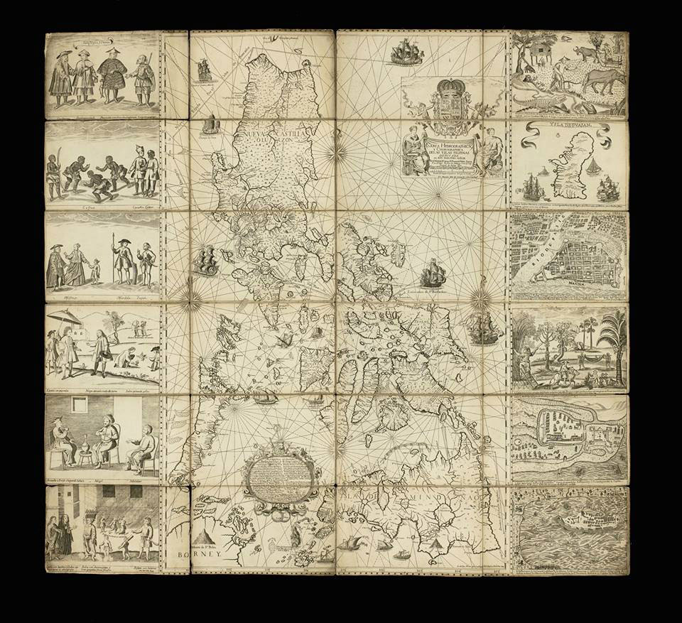
. . . . Justice Carpio, who was the guest of honor and main speaker at the Alliance Française, said “the 1734 Murillo Velarde map is a living document because it determines Philippine territory today, that is, Philippine territory cannot be determined without this map.” This oldest Philippine map of “Las Yslas Filipinas” is the official Spanish Government map showing Philippine territory during the Spanish regime. It shows Panacot (Scarborough Shoal) and Los Bajos de Paragua (the Spratlys) as part of Philippine territory, Justice Carpio said. None of these islands drawn in this Murillo Velarde map appeared in China’s maps from centuries ago.
“The map debunks once and for all, the Chinese historical narrative that China has owned the South China Sea for 200 years. Now the world knows better. Thanks to the definitive ruling of the Arbitral Tribunal, China’s historical narrative has been exposed as fake news. The map proves, beyond any shadow of doubt, that Spratlys and Scarborough Shoal were part of the Philippine territory as early as 1734,” Justice Carpio had said at a lecture at the Ateneo de Manila University in 2017.
At the Alliance Française opening, Justice Carpio explained that the aggressiveness of China in claiming the Spratlys and Scarborough Shoal started with the 1898 Treaty of Paris, after the Spanish-American war, when Spain ceded to the United States the archipelago known as the Philippine Islands in exchange for $20 million to ratify the Treaty. Spain might have missed the Spratly Islands and Scarborough Shoal, putting these outside the western side of the polygonal lines of the Philippines in the Treaty of Paris.
But the United States noticed the exclusion, and demanded a revision of the map for the revised treaty, called the 1900 Treaty of Washington, which provided that “Spain relinquishes to the United all title and all claim of title, which she may have had at the time of the conclusion of the Treaty of Peace of Paris, to any and all islands belonging to the Philippine Archipelago, lying outside the lines described in Article III of that Treaty and particularly to the islands of Cagayan (Mapun), Sulu and Sibutu and their dependencies, and agrees that all such islands shall be comprehended in the cession of the Archipelago as fully as if they had been expressly included within those lines.”
The frame of reference for the 1900 Treaty of Washington’s definition of the Philippine territory was the Murillo Velarde map, which included the Spratlys and the Scarborough Shoal, But still, China’s position is that Philippine territory is limited to the islands enclosed by the polygonal lines drawn in the 1898 Treaty of Paris. Justice Carpio said that China did not participate in the Arbitral proceedings, but “by officially submitting its Position Paper to the Arbitral Tribunal, China expressly and formally recognized that Philippine territory is defined by three treaties, including the 1900 Treaty of Washington… China is forever estopped from claiming that Philippine territory is limited to the islands enclosed by the Treaty of Paris.”
It was only in 1947 that China started to claim the Spratlys, Justice Carpio said. Scarborough Shoal appears in a 1948 Chinese map, named Si-ka-ba-luo, a Chinese transliteration of the English name Scarborough, The shoal was named by Captain Philip D’Auvergne, whose East India Company ship East Indiaman Scarborough grounded on one of the rocks on Sept. 12, 1784, before sailing on to China although it already had a Spanish name recorded in the 1734 Murillo Velarde map of Spanish Philippines (W. Gilbert [1804] A New Nautical Directory for the East-India and China Navigation .., pp.480-482).
The Carta Hydrographica y Chorographica de las Islas Filipinas, the Murillo Velarde 1734 map is indeed the “Mother of all Philippine Maps,” a “Living Document” to history, as Justice Carpio says.
Filipinos thank Justice Antonio Carpio for his unrelenting fight for Philippine territory and maritime sovereignty in the West Philippine Sea (South China Sea).
We thank Former Secretary of Foreign Affairs and Ambassador Albert del Rosario, who had fought together with Justice Carpio for Philippine rights on the seas. Ambassador del Rosario, 83, passed away on April 18. May he rest in peace.
“The mother of all Philippine maps” by Iris Gonzales
https://www.philstar.com/opinion/2023/04/27/2262008/mother-all-philippine-maps
[…] Scarborough Shoal and the Spratlys in ancient maps […]
AMELIA HC YLAGAN: “The 1875 Carta General del Archipielago Filipino”
This is it!
“This map of the Philippine Archipelago was first published in 1875 by the Direccion Hidografia and reissued in 1888 with minor corrections. This map shows ‘B. Masinloc,’ and almost all of the Spratlys, including Thitu (Pagasa) island. All the islands of the Kalayaan group are in this map. This is the last of the official maps of the Philippines published during the Spanish regime. This is the definitive map depicting all the islands of the Philippine Archipelago.”
Those were the opening words of former Supreme Court Senior Associate Justice Antonio Carpio at the National Library of the Philippines on March 19, where he donated a full-size copy of the official map that defined the Philippine territory ceded by Spain to the United States in the settlement of the Spanish-American War which started on April 25, 1898 and ended on-Dec. 10, 1898 with the Treaty of Paris. Specifics of the cession of the Philippines were later clarified on Nov. 7, 1900, when Spain and the United States signed the Treaty of Washington.
That’s what started the confusion and misunderstanding about the islands included in the Philippine archipelago, Mr. Carpio said.
“The map attached to the Treaty of Paris did not correspond to the geographical coordinates fixed by US negotiators and listed in the Treaty. The geographical coordinates did not include Cagayan de Sulu and Sibutu as Philippine territory. They did not include many islands of the Spratlys as Philippine territory….
https://www.bworldonline.com/opinion/2026/03/23/737892/the-1875-carta-general-del-archipielago-filipino/